Connected to California’s 60s counterculture due to its untrammeled wilderness, dramatic vistas, surf waves, and legendary sunsets, Big Sur has been perceived by pop culture as one of the chosen places of itinerant hippies and intellectuals of yesteryear, a place where in the 60s’ “young people lived in cars and under the bridges” while nobody talked about housing crisis or homelessness.
But Big Sur’s steep cliffs tell more than the fractal experimentation of the Esalen Institute, decades before the “holistic retreat” welcomed visitors with a sign warning a clearcut “by reservation only”: geologically, the place’s impenetrable chaparral, redwoods, and steep canyons plunging into the blue ocean was known by native tribes first, and later by the Spanish Franciscan missionaries settling in California Nueva, for the rivers of debris washed by the rains and massive mudslides cyclically striking the area.

Founded by Michael Murphy and Dick Price, the Esalen Institute inspired its ethos from the Esselen Indian’s belief that the area’s warm sulfur pools had healing qualities. The initial spiritual and contemplative takes came to the test soon afterward, when the founders were accompanied by famous regulars like Joan Baez to calm the expectations of newcomers traveling down from San Francisco just to party.
A bathhouse perched over the Pacific
Meanwhile, not only were the mission statement and financials of the Institute on bad footing, but slight erosion caused by rain and earthquakes prompted little maintenance interventions, though some of the structures remained in precarious condition given the terrain’s inherent instability. But then, in 1998, El Niño rains created the perfect storm for a mudslide to form nearby, destroying the original Esalen bathhouse.
Now, warmer overall temperatures and El Niño cycles in the central and eastern Pacific Ocean change precipitation patterns and aggravate their intensity, as more moisture increases precipitation in some regions while others experience severe droughts. The remains of the original Esalen bathhouse stand as minutiae compared to what’s coming, as fires, mudslides, and water floods concentrate in some of the most sought-after (and expensive) real estate areas of Central and Southern California.
In January 2018, heavy rains were followed in Montecito, California, the exclusive hillside community just outside Santa Barbara, by massive debris flows and mudslides, killing over 20 people. David R. Montgomery, Professor of Earth and Space Sciences at the University of Washington, explained why such events are likely to grow:
“As mountains rise, erosion tears them down. And Southern California’s mountains are rising fast, squeezed up by the action of the region’s active faults. This produces steep slopes that erode quickly, though much of that erosion happens in infrequent events, such as big rainstorms right after big wildfires.”
And so, California has sleepwalked from talking about severe drought to issuing landslide warnings in places with little vegetation where the soil can’t take more water without risking landslides in a second wetter-than-expected year in a row.

Historically, landslides have received far less public attention than fires, earthquakes, or volcanoes eruptions despite killing more people per year in the US than such events.
Fire, rain, and debris
Scientists and planners have known for decades that “the mountains of Southern California are shaped by a cycle of fire, rain, and debris flows,” which reads like the Biblical curse Joan Didion loved to write about. Even solving some of the area erosion problems won’t reduce the risk of marginal increases, experts believe. And the consequences are already straightforward for everyone to see: recently, a spectacular cliff landslide in the exclusive Orange County enclave of Dana Point left a few houses on the brink of tumbling down to the ocean.

A video by ABC News shows the landslide from the air, leaving three mansions in a more than precarious situation. Their value hasn’t been updated, given the risk they face. Currently, they are still priced at $16 million, $12.8 million, and $13 million. Given the liability of any property owner who owns a house near the water (required to clean any debris that falls into the ocean and a potential fine plus a high fee per day if it’s not removed), the real price of some of those houses could be marginal, and they could lose their insurance coverage (if they happen to have it).
Similar homes on the cliff tops at La Jolla and other exclusive areas will become a riskier investment in the future. Meanwhile, Insurance companies are reconsidering, if not fleeing, most areas considered at risk from extreme weather in California, whereas State Farm and The Hartford stopped accepting new applications in mid-2023. They allege that they had no other option after a sharp rise in the cost of “property catastrophe reinsurance,” that is, the cost of insurance for insurance companies.
The shadow of deep-seated landslides
Geologically, California sits atop young mountains and valleys, causing areas next to steep terrain and watersheds to remain in motion. And so, heavy rain episodes like the recent atmospheric rivers make rocks loose as some homeowners are learning the consequences the hard way: if erosion makes deforested areas especially prone to mudslides, are mountain and coastal houses on steep terrain safe at all?
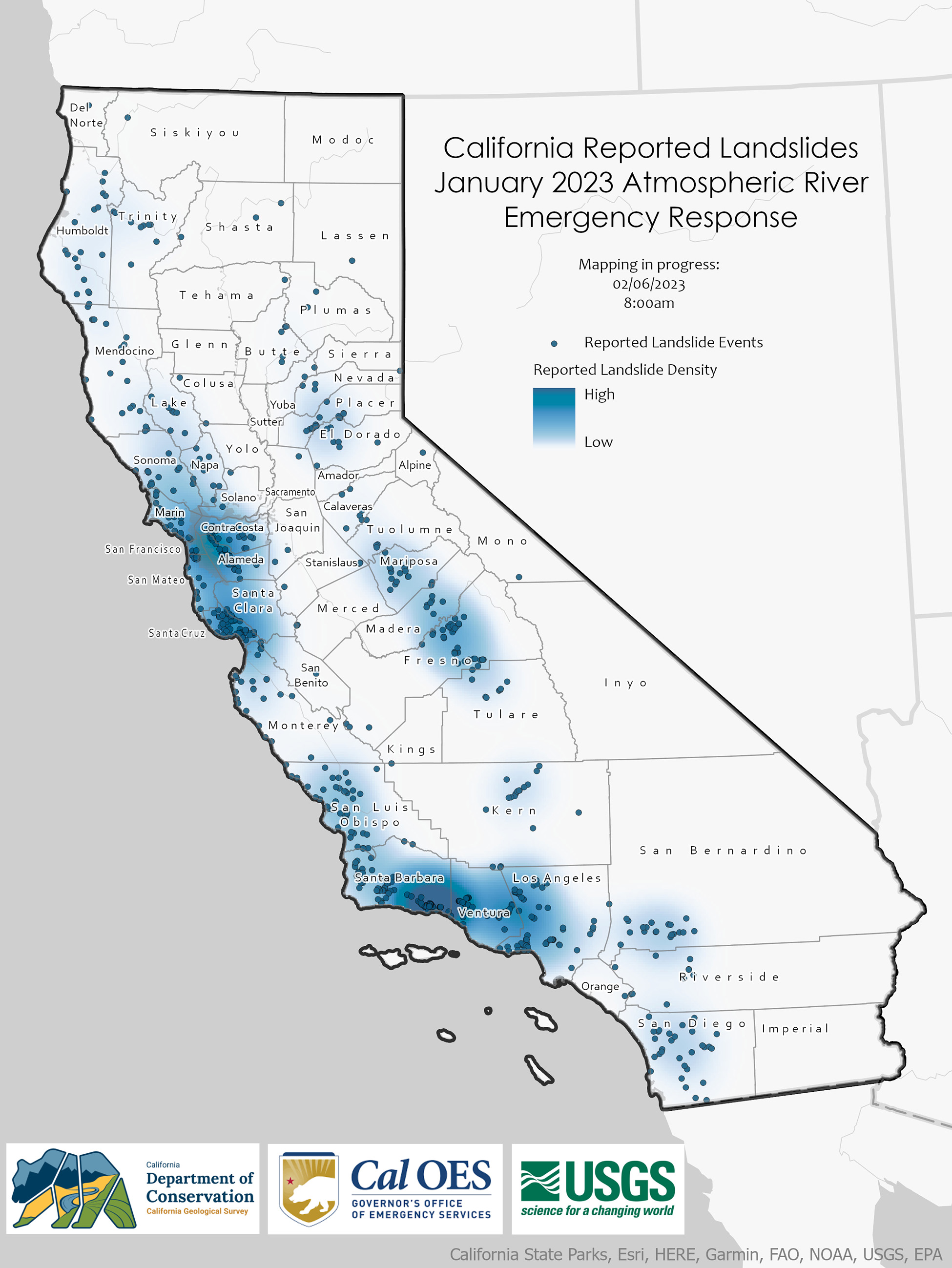
The answer is complicated, to say the least. The California Department of Conservation updates a landslide database to use as real-time feedback for a response team that has to cover a vast extension from the Sierras foothills to the cliffs and canyons of coastal Northern, Central, and Southern California.
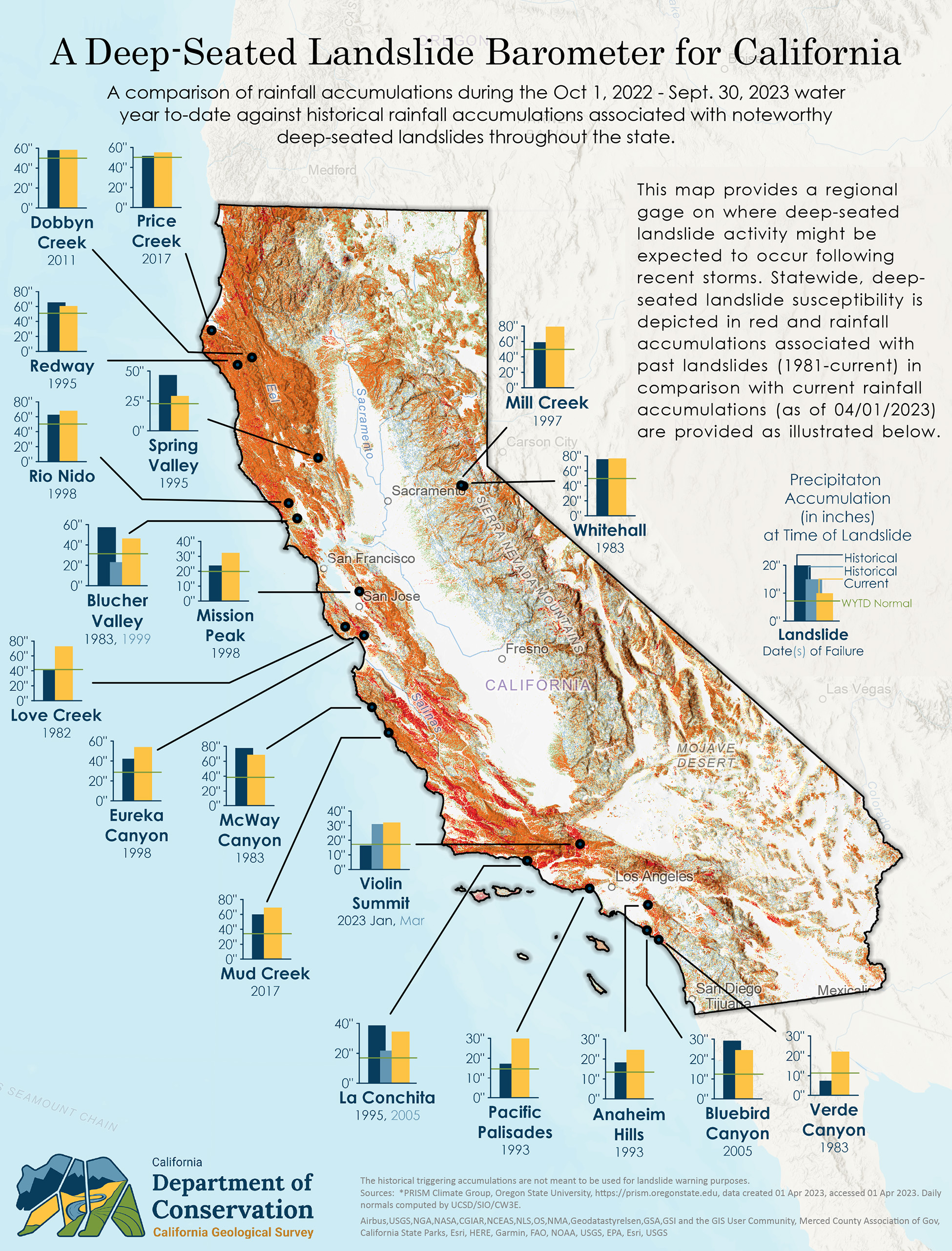
State Geologists have tried to raise awareness of a growing phenomenon across the areas West of the Rockies where increased precipitation anomalies have concentrated, triggering the risk of deep-seated landslides, which don’t relate to any single storm or earthquake and can occur “weeks or months after heavy rainfall ends.” By the time they happen, water has percolated deeper under the surface, saturating zones of rock and creating a “landslide plane”:
“Because these landslides begin so deeply, they tend to carry more material and cover more territory than other types of slides. Deep-seated landslides generally occur on moderately steep slopes, often travel much slower than debris flows or mudflows (maybe only a few inches a day), and can continue for several days.”
Using reported landslides and a historical comparison of rainfall accumulations, California’s Department of Conservation has created a barometer of deep-seated landslides that shows an overall increased risk across the State. The phenomenon isn’t new, and some of the most significant reported events date back several years if not decades. A 2011 map sheet based on geological surveys, average annual rainfall, earthquake shaking potential, slope inclination, and rock strength:
“These classes express the generalization that on very low slopes, landslide susceptibility is low even in weak materials and that landslide susceptibility increases with slope and in weaker rocks. Very high landslide susceptibility, classes VIII, IX, and X, includes very steep slopes in hard rocks and moderate to very steep slopes in weak rocks.”
Susceptibility to Deep-Seated Landslides in California, C. J. Wills, F. G. Perez and C. I. Gutierrez, California Geological Survey (2011)
Mudhills aren’t as fun as Woodstock’s
Bluebird Canyon in Laguna Beach (Orange County) suffered deep-seated landslides in 1978 and again in 2005, following heavy rains during the wet season in both cases. On the other side of the heavily urbanized Los Angeles area, La Conchita Canyon (Ventura County) suffered two landslides a few days apart in 1995, covering a 10-acre area and moving 1.7 million cubing yards of debris, enough to fill the Rose Bowl Stadium twice. That’s a lot of dirt, and extreme weather will likely make things worse as suburban and exurban developments have gotten closer to hills and canyons in areas like Greater Los Angeles and San Diego.
Local communities especially prone to deep-seated mudslides are being encouraged to learn how to be more proactive in the search for signs of impending terrain changes, then contact local authorities if they see any signs:
Check for new cracks in the soil, structural shifts in your home (doors/windows that suddenly don’t close properly, for example), the appearance of holes or bare spots on hills, tilting trees or bulges at the base of slopes, or material moving downhill.
Watch for new springs or seeps and excess surface erosion on slopes on and around your property. If there are nearby streams, do they appear muddier than normal?
Listen for unusual rumbling sounds or noises that may indicate moving earth and rocks or breaking vegetation or structures.
Likewise, broken water and gas lines or noises in your plumbing may indicate that pipes are being pulled apart.”
Near a Slope? Know the Signs of a Deep-Seated Landslide, 2023 California Landslide Response, California Department of Conservation
Despite the efforts to create a preparedness culture, CGS (the geological survey division at California’s Department of Conservation) can do little but issue technical reports of disasters once they have happened. Several studies have confirmed the relationship between paving and developing formerly rural areas and an increased risk of floods and landslides caused by precipitation, since housing developments and road and highway corridors can exacerbate the phenomenon, decreasing the soil’s permeability.
Reactive disaster management: a job with a future
It’s not only more intense El Niños that concerns the people at CGS: major wildfires during the last two decades have caused a bigger risk of debris flows after heavy rains. Fire, flood, and mudslide prevention will go hand in hand in the future, requiring a collaboration that will determine the success of pivoting from a culture reactive to natural disasters and extreme weather events to a more proactive approach.
Swiss Re Institute’s 2019 report states that, in 2018, the world accumulated losses of at least $176 billion in 2018. And, as expenses mount, the whole insurance sector is rethinking its strategy. But, what happens to entire populations left uninsured? Most of those living in areas where extreme events have increased could understand higher premiums in their contracts, though companies are pulling out for good from some of the US’ biggest markets.

Everyone understands that reactive disaster management (responding to a crisis after it has occurred) can be immensely costly for businesses and individuals. But how do we convince people, towns, counties, and entire states to make costly decisions to prepare for things that may happen soon or not happen for some years or decades in the best-case scenarios? Behavioral psychology has shown one time and another how difficult and counterintuitive abstract preparedness can be for humans, with nation-state-wide exceptions like Japan (and its earthquake and forestry policies) or The Netherlands (a country that has learned the hard way to effectively protect itself from the North Sea’s virulent storms, while “terraforming” an ever-growing portion of its underwater land mass by building artificial islands, or polders.
An in-depth article by the British pink tabloid Financial Times says it all on its header: The Uninsurable World:
“A run of four consecutive years when overall insurance losses from natural catastrophes have topped $100bn, previously the mark of a remarkably bad year, has spooked executives.”
The article shows how preparedness is already working as humanity adapts to extreme weather: more frequent and severe events have augmented economic losses, “but improved evacuations have reduced death tolls.”
Contingencies of our time
Last year, 37 events with losses of over 1 billion dollars each represented an all-time record:
“That included 25 so-called severe convective storms, of which 21 were in the US. It is the growing weight of events such as storms and wildfires — and the broadening of the areas that are exposed to them — that is raising anxiety in the sector, and changing the way risk is viewed.”
So far, the year-to-year growth seems exponential, and insurers don’t want to take the risk with moderately adjusted premiums. If the losses are exponential, who is to pay the difference? Reactive disaster management experts believe that the only way to achieve long-term success is to become better and more proactive in saving not only lives but also properties during disasters.

Artificial intelligence will help create better weather prevention, but which regulations and technologies will prevent properties from suffering from floods, fire, hurricanes, or landslides? In their article for the Financial Times, Ian Smith, Attracta Mooney, and Aime Williams state that “Rising home premiums are a de facto’ carbon price’ on consumers as extreme weather events become more frequent.”
Insurers are also warning that premiums will go up eventually everywhere. In Europe, serious drought in the Mediterranean Basin, increased fires, and bigger floods are the culprits, depending on the area. Australia has been facing extreme temperatures in most of its territory, whereas some of the most recent fires have been devastating.
Real risk, or the perfect excuse to raise premiums?
Christian Mumenthaler, chief executive of Swiss Re, one of the world’s biggest reinsurers, comes with news no one wants to listen to, explains the Financial Times:
“Rising insurance premiums were a kind of carbon price on consumers, he said, with higher costs resulting from ‘us living the way we’ve been living’. He added: ‘But of course [consumers] don’t like it and the politicians don’t like it.'”
To be fair, insurance companies didn’t like to hear about the bad news either. Executives tell in private that the risk-modeling companies the insurers relied on to model forecast losses had underplayed the effects of extreme weather events as overall temperatures rise. As a consequence, nobody wants to pay the unexpectedly high bill: not the insurers, not the insurers’ insurers, and certainly not the customers.

“The cost of property catastrophe reinsurance cover, which they use to share the burden of natural disaster claims, is at its highest in a generation. Reinsurers have also sharply raised their so-called attachment points — the level of losses that need to be reached for the reinsurance to kick in.”
For four consecutive years, overall insurance losses from natural catastrophes have surpassed the psychological barrier of $100 billion. If yearly losses stick over $100 billion consistently, firms will try to protect their margins, and the strong incentives of preparedness (and survival) will stimulate legislation and technology to build and maintain resilient systems built with redundancies that help weather contingencies. Will people facing the most risk relocate, or will we build sturdier, easily repairable structures?